Maps and site plans
Your site to scale,
ready to measure.
The drone flies a fixed pattern above your site and takes hundreds of photos. From those we calculate one sharp image looking straight down: an orthophoto, to scale. For measuring, for planning, and for showing what is there. Below is a real one: the Sjûkelân in Franeker, during the Agrarische Dagen.
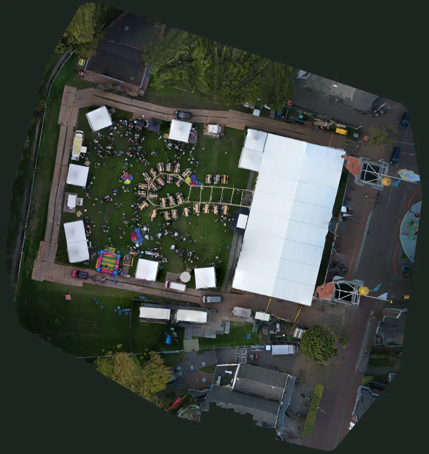
Sjûkelân, Franeker · 18 September 2026
A site of roughly 105 by 111 metres, at 5 centimetres per pixel. With Map underneath you place it on the aerial photo or the map of PDOK, exactly where it belongs; with the Orthophoto slider you see the base map through it, and the same button removes the map again. Turn on Measure and click points to measure a distance; click the first point for the area. With Plant health you see where the grass is doing well, and where the road plates are.
What you get
One flight, a complete map.
The same photos produce several maps. You choose what you need; we deliver it in files you open in your own software, and as a regular image to share.
- An orthophoto: one sharp image looking straight down, to scale and with coordinates (GeoTIFF), that fits exactly on a map
- Measurements of distances and areas, as in the map above
- An elevation map of the site, and a 3D model to look around
- A plant health map, as an indication for grass and crops
- The same place again later, to see the change
Who it is for
For anyone who needs to lay out, follow or show a site.
- EventsThe real layout of your grounds: where the tents are, where the road plates lie, and what could change next year.
- Construction and earthworksThe progress of a project on a map, month after month from the same height.
- AgricultureYour fields from above, with an indication of where the crop is doing well or less well.
- Real estate and councilsAn up-to-date aerial photo of a plot or area, sharper and newer than the online maps.
How it works
From flight plan to map.
- 01
Flight plan
We outline the site and set the height. The lower we fly, the more detail.
- 02
Flying
The drone flies over the site in lanes and takes hundreds of photos that overlap generously.
- 03
Processing
From all those photos we calculate the orthophoto, the elevation map and the 3D model (photogrammetry).
- 04
Delivery
You get the files in your client portal, ready for your own software or to share.
Price
Based on the size of your site.
The larger the site and the more detail, the longer we fly and process. Send us the location and what you want to do with it; you get a fixed price in advance.
Questions
Good to know.
What is an orthophoto?
An aerial photo in which everything is seen straight from above and at the same scale, right up to the edges. That means you can measure on it, just like on a map. It is made from hundreds of separate photos that together form one image.
How accurate is it?
The example above has 5 centimetres per pixel. Flying lower gives more detail. For planning, laying out and comparing that is plenty; for official surveying or cadastral boundaries you still need a land surveyor.
Which files do I get?
A GeoTIFF with coordinates, which you open in mapping software such as QGIS, and a regular image to share or print. On request also the elevation map and the 3D model.
What does the map say about plant health?
From the colours in the photo we calculate an index that shows where green is healthy green and where it is bare, dry or paved. It is an indication from a regular camera, not a measurement with a special camera, but it quickly shows where to take a closer look.
Are you allowed to fly anywhere?
No, and we check that in advance. Near airports, over nature reserves and over people, restrictions apply. We check the airspace before every flight, and where permission is needed, we apply for it.
You might also like
Which site shall
we put on the map?
Send us the location and what you want to do with it. You will hear from us within two working days.